Getting From San Jose to Panama
The drive from Monteverde to San Jose was quite nice. The dirt road out of Monteverde was under construction, and the road was only open for 40 minutes at a time every 3 hours, so we had to leave a bit earlier than we had anticipated. We stopped to gas up the car at the gas station about 15 minutes out of town, and Amy realized she had forgotten her new Monteverde hat! We thought about going back to the hotel to get it, but we had locked the key in the room and the office would probably not yet be open, so we decided to press on (more about the hat later). We had heard from locals in town that occasionally trucks and busses back up at the closure and we did not want to risk it. As it happened, we made it to the closure point with time to spare. It was one-lane driving down very, very stepp mountain roads with steep dropoffs, but compared to the road we had taken into Monteverde, was no big deal.
After we made it the #1 road, it was pretty smooth sailing. The GPS kept telling us to take a different route, which seemed wrong to us, but we did not have a 'big picture' road map, so we stuck with the #1 road, which locals had told us was the way to go. Eventually we got paranoid that we were heading the wrong way, and really didn't want to miss our bus at noon, so we stopped in at a gas station. We bought a map, and sure enough, the GPS had been right the whole time and was trying to put us on a toll road that would have been much more direct than the #1 road. We were pretty close to San Jose at that point, so we decided to not worry about it and press on.
The rental car office was in the middle of downtown San Jose, and it made for some exciting driving. Amy did a great job navigating, and we made it safe and sound into the parking lot...when we remembered that we needed to top off the tank. So back into the thick of downtown San Jose, we found a gas station (closed), found another, gassed up, and back.
Unfortunately, the people running the rental car office were not there when we showed up. There were a couple of workers busily loading vans with files and office furniture, and they told us that the two workers would be back within about 10 minutes.
About thirty minutes later, they finally showed up. It took *forever* to process our paperwork, and then they gave us a lift to the Tica Bus office. By this point, we were running pretty late. We got into various lines, paid various fees, filled out various forms, and squeaked onto the bus with about 3 minutes to spare. Whew!
The bus was very modern, and fully operational--it is hard to describe what a marvel it seemed to be riding on a bus with functioning air conditioning, a functioning toilet, and even--holy smokes!--movies! We were psyched. Then the movie started.
I realize that Central Americans have a different culture than what we're used to in the USA. They have different morals, and different values. But I really have to question their movie choice--it was Troy. For those of you that've seen it, you know what I'm talking about. If you haven't seen it, it is a 3 hour long epic about Troy vs Sparta, starring Brad Pitt, and is chock-full of the most graphic violence and sex you can possibly imagine. I'm talking spurting aortas, decapitations, thrusting buttocks, and bouncing breasts, all there, in full color, completely surrounding our children. We were somewhat aghast. So we whipped out the tablet, stuck headphones in the boys' ears, and told them not to look up. For three hours. This worked pretty well, but at one point, Lochlan did look up, and he said later "all I saw were piles of skin on top of each other. It was kinda weird."
 |
| Just thought we'd take the bus to dinner. Literally. |
We stopped for food around 4:00 at a most unusual but very pragmatic roadside dining facility. It appeared to have been purpose built by the bus company, because it had an enormous roof with room for 3 buses to park right next to a dining area. In front of the dining area was a cafetera line with lots of affordable food options. The whole thing was pretty slick. I think they were expecting us, because there was a lot of food and it was all fresh. We weren't hungry but intuited (correctly) that this would be our last chance for food for quite some time.
Back on the bus, we drove for another seven hours or so before we made it to the border with Panama.
Entering Panama
Panama was the most militarized and difficult border we encountered on our trip. There were very long lines, the immigration officials were rude, abrupt, and unhelpful, and then all ofthe passengers on our bus were shepherded into a small, stifling room and made to wait for about half an hour. Eventually, when everyone was soaked with sweat, thirsty, and tired, three customs officials came in. They took a 'roll call', just like in elementary school. "Javier Garcia...?" "Presente." Etc. Finally they came to our family, and boy did the guy struggle with the boys names. He did OK on Liam, but when he got to Lochlan, he got stuck on "Lo...lo...lo..." so I said "Lochlan" and all of the Spanish speakers in the room started laughing, because the name is so hard for them to pronounce.
They searched everyone's bags. Fortunately, as the only passengers with kids, the guy who was supposed to search our bags just waved us on, which was nice.
We got back on the bus and promptly fell asleep. We woke up at 3:45 am inside of...a mall. Yes, a shopping mall. Quite easily the largest shopping mall I have ever seen. The bus station is inside the mall. Along with just about every kind of store you can imagine. We staggered off to find an ATM, took out some money (Panama uses the US Dollar, which is kind of weird, but convenient) and then found a scrum of taxi drivers. They all really wanted our fare. I instigated a bidding war, and got our fare down to $6.
 |
| This was our view as soon as we stepped off the bus. |
We arrived at our hotel, and the front desk guy was super-duper cool and let us check in 11 hours early. We tramped up the stairs, dropped our bags, and fell deeply asleep.
We awoke the next morning to discover that we were staying in an American chain hotel--the Comfort Inn and Suites, complete with attached TGI Fridays. It was surreal, but again, very convenient--most of the staff could speak flawless English, and everything was easy to figure out. The beds were nice, all of the plumbing worked, the free breakfast at the hotel restaurant was bountiful and tasy, the pool was clean, and best of all, the hotel had a view of the entrance to the canal and the bridge of the Americas. That was cool.
We wanted to explore a little bit, so we walked about a mile to the bike rental place at the beginning of the causeway. All of the bikes were locked up and there was a tarp covering the whole set up. We thought we were SOL, but the guy showed up, and we managed to rent four bikes, including two kid bike! We rode south along the causeway. The Amador causeway is an artificial roadway that extends for about 2 miles south from the canal and connects the mainland to three islands, Naos, Perico, and Culebra. The causeway was built by the Americans as part of the canal in order to serve as a breakwater and compensate for the extreme tides on the Pacific side of the canal.
There is a very nice bike path that runs the length of the causeway, with great views of the ocean, the city, and the ships waiting to transit the canal. There is also a Frank Gehry-designed building, the Biodiversity Museum, near the beginning of the causeway. It is a very colorful structure, but ugly, confusing, and full of unusable spaces, just like the rest of his buildings. It was supposed to open at the end of 2013 but was still under construction when we were there.
 |
| Biking on the Amador Causeway |
 |
| Looking north towards the city skyline |
 |
| Not a bad beer, actually kind of refreshing on the super hot day |
 |
| Frank Gehry, or at least his work, is apparently everywhere |
At the end of the causeway we passed lots of restaurants and a couple of marinas. We found a little pizza joint, ordered our pizza, then had some cold beverages and watched the World Cup with the wait staff while we waited.
Transiting the Panama Canal
The next day was a big one--we transited the Panama Canal! I've wanted to transit the Panama Canal since I was a kid and had been looking forward to this for months. We even re-jiggered our schedule a bit for this tour, the company only does one full transit a month! In anticipation of our trip I read the excellent book The Path Between the Seas by David McCulloch. If you are at all interested in the Panama Canal, you should read this book! He does an excellent job covering the entire history of the project, from the failed French attempt, through the eventual hand off to the Americans, and all the associated political machinations and other shenanigans that were necessary to make it happen. There is even a Washington state connection--the second chief engineer, John Frank Stevens, built the Great Northern railroad through Washington, and discovered Stevens Pass, which is named after him.
We took a taxi from our hotel to the Flamenco Marina at the end of the causeway, waited in a long line to check in, and then we boarded the Pacific Queen. The boat was surprisingly big--four levels, over 300 passengers. It was very cloudy, and there were even a few raindrops as we waited to depart.
 |
| Our boat, the Pacific Queen |
 |
| Ready to depart! |
A woman dressed in traditional Panamanian clothing ("La Pollera") made the rounds and posed for photographs with the passengers. Lochlan was a bit too embarassed to pose with her, but we were able to convince Liam.
 |
| Liam being a good sport |
Eventually, we left the marina and cruised clockwise around Isla Flamenco. We could see all of the big ships, and many smaller ships, awaiting their turn to enter the canal. Shortly after we rounded Isla Flamenco, a pilot boat approached and our Canal pilot came aboard. All boats transiting the canal have to have a Canal Pilot on board, and he is in charge of the vessel the entire time it is within the Canal Zone. With pilot safely aboard, we headed northwest, towards the bridge of the Americas, and then we were in the Canal Zone.
 |
| Our Canal Pilot steps aboard |
 |
| Bridge of the Americas |
The first set of locks ships encounter when heading from Pacific to Atlantic is the Miraflores. There are actually two locks in succession. We entered the locks with two other vessels, the Ocean Harvest (a freighter of some sort) and the Tuira II, another tour boat. The scale of the locks is astounding, they are just stupendous. Everything looks overbuilt--the doors, the hydraulic arms that open and close them, the concrete sides of the canal, the bollards, everything.
 |
| Entering the first lock |
 |
| Friendly Canal workers |
 |
| Massive, massive doors |
 |
| The Miraflores visitor center |
 |
| We transited during the Centennial year |
The canal workers took our dock lines, made sure we and the other two ships were secure, then closed the gates. The water rose with surprising rapidity. The bottom of the canal is lined with hundreds of 2.5' diameter holes, and valves are opened to move water from the higher elevation lakes into the locks.
The large ships maintain their position within the locks with the assistance of 'mules', very powerful electric trains that use pulleys and cables to ensure the ships don't grind against the sides of the canal. The mules have always been electric, since the first day of the canal, and at the time electric trains were a brand-new technology. They (and a lot of other newly invented equipment throughout the canal) were built by a little technology and engineering start-up company called General Electric. (They've done okay since then, maybe you've heard of them?)
 |
| One of the Mules. The current batch were made in Japan by Mitsubishi |
After repeating the process in the second of the Miraflores locks, we entered Miraflores Lake, the first of two artificial lakes that comprise the majority of the distance covered by the canal. At the north end of Miraflores Lake, we entered the Pedro Miguel lock, and completed the 85' elevation gain from sea level on the Pacific to the elevation of Gatun Lake. At the time it was built, Gatun dam was the largest dam in the world, and Gatun Lake was the largest artificial lake. However, before we could enter Gatun Lake proper, we had to traverse the Gaillard Cut.
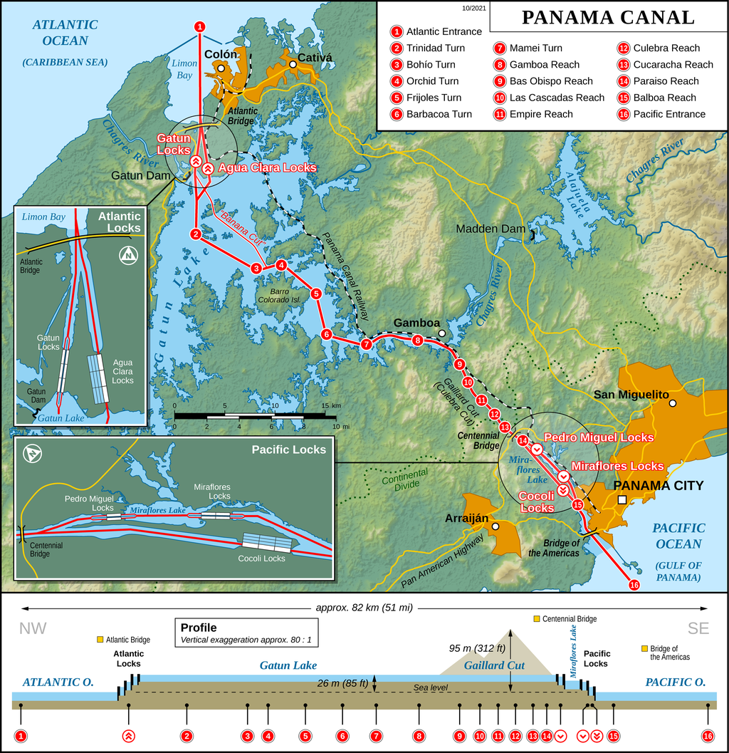 |
| Map of the Canal, illustrating the relative position of the locks and the Culebra Cut |
The Culebra Cut, formerly called the Gaillard Cut, was the most challenging stretch of the entire canal, and this is where the vast majority of the excavation occurred. There were many large landslides in the Cut, and they continued even after the canal opened, causing numerous closures.
 |
| Approaching the cut |
 |
| This mountain has had so much material removed it looks a bit like a Mayan temple |
After we left the Cut we entered Gatun Lake, and steamed along for about two and half hours. We passed Isla Barro Colorado, the largest island in the lake, and one of the most biologically diverse spots on the planet. The Smithsonian institute has a large research facility there, and we caught a glimpse of their dock and some of their buildings as we passed.
 |
| Amy and the boys looking for wildlife in Gatun Lake |
Surprisingly, we did not pass a lot of other ships. I learned later this is by design, because they Canal Authority does not want ships passing each other in the Cut, so they stagger the transits to minimize congestion. We also did not see any sailboats, which should not have been surprising since we were there at the beginning of hurricane season, but it would have been nice to see at least one.
At the northwestern end of Gatun Lake we saw Gatun Dam (which holds back the Chagres River) and waited in front of Gatun Locks for our 'buddy boats' to arrive. Once everyone was in place, we entered the first of the three sequential locks and began our descent to the Atlantic. The process was identical to our trip up to the lake, only in reverse. At one point as our ship was being lowered in the middle canal, I could look behind us and see ships on the lake, and look in front of us and see ships on the Atlantic. It was very cool!
 |
| Our lock partner joining us at the Gatun Locks |
 |
| Looking down to the Atlantic |
 |
| The gates of the final lock open |
 |
| These look a bit like condos, but they are actually lock gates! The Canal Authority is in the process of building a third channel through the canal to allow bigger ships to pass, and the new locks dwarf the current locks |
We entered Limon Bay as the sun was beginning its descent, and saw about a hundred ships waiting for their turn to transit the canal to the Pacific. Most of the big freighters pay between $100,000-$400,000 *each* to transit, and as I stared out at all the waiting ships, I couldn't help but envision the torrent of cash that pours into Panama via the canal every day. It is a truly staggering engineering marvel, but it is similarly impressive from the economic perspective too.
 |
| Money money money, just floating on the sea |
We turned to the northeast and saw the skyline of the city of Colon. There is a large breakwater across Limon Bay, but there is still plenty of room for the waves to build, and we saw several ships that had dragged anchor over the years and crashed into the waterfront of Colon. A couple of them looked like they'd been stripped and were in the process of being broken down, but apparently most of the owners just abandon them to rot because it is so expensive to remove them.
Our boat docked at the municipal pier and we were hustled onto buses for our drive back to Panama City. We'd heard from several sources that Colon is a dangerous cesspool, and based on the few minutes I saw from the bus, I would have to agree. It made Belize City look like Singapore. There were drifts of trash on almost every street, decaying buildings, lots of shady looking characters just standing around, and filthy, dark, narrow alleys that looked like great places to get mugged, raped, or murdered. I was thankful we were heading straight back.
We were able to talk the bus driver into dropping us off at our hotel (which was on the way to the marina) and we ate a late dinner at the hotel restaurant, then collapsed into bed. It had taken us 13 hours to transit the canal and drive back to Panama City.
Touring Panama City
The next day we hired a taxi driver to give us a tour of the city. We started with an overview of the Canal Zone, and we saw the monuments to John Stevens and George Washington Goethals (the chief engineer from the U.S. Army Corps of Engineers who finished the canal) along with the Administration building. We also saw hundreds, maybe thousands, of buildings within the Canal Zone that had been built by the Americans during the construction period. There were loads of houses and apartment buildings, as well as hospitals, offices, machine shopes, and on and on. They are all being re-used by the Panamanians in one form or another, and that was interesting to see.
 |
| Monument to John Stevens |
 |
| Monument to George Washington Goethals, with the Administration Building in the background |
We went to the Miraflores Visitor Center, which is at the Miraflores Locks, and I was *pretty sure* Amy would kill me for returning to the locks after spending AN ENTIRE DAY going through them the day before. However, we got a really different perspective of the canal from the top of the visitors center, and there were many excellent displays inside the museum. We only stayed for about an hour and a half, then it was on to Ancon Hill.
 |
| Checking out the locks from the top of the Visitor's Center. Lochlan was not into it. |
 |
| The first two Chief Engineers, John Wallace on the upper left and John Stevens on the bottom right |
 |
| The boys standing in a room representing the size of the tunnels that move water into and out of the locks |
Ancon Hill dominates the skyline of Panama City and it has excellent views of both the old city (Casco Viejo) and the new city. The hill is also full of remnants of the American period, and we even saw a couple of Cold War era bunkers! There is an enormous flag flying on top of Ancon Hill, and our taxi driver/guide told us it is the size of a tennis court.
 |
| On top of Ancon Hill. The new city is on the left, Casco Viejo is on the right |
 |
| The huge Panamanian flag |
We descended Ancon Hill and entered Casco Viejo. Panama City was relocated here in 1671 after Captain Henry Morgan (yes, that Captain Morgan) burned the original Panama City to the ground. It is a very charming old city, similar to the others we've seen, but seemed to be in even better shape. I suspect the Panamanians have a bit more cash to throw into these projects than the other countries we visited! We saw numerous monuments, churches, government buildings, and grand hotels. We even saw the Presidential Palace! Surprisingly El Presidente lives right in the middle of the oldest part of the City, and after exchanging a few words with the guard at the end of the street in front of the palace, we were able to walk right up to it and pose for photos!
 |
| Statue of Tomas Herrera, the first head of state of the Free State of the Isthmus |
 |
| Some of the buildings are rather old |
 |
| The main cathedral |
 |
| Another view of the cathedral |
 |
| In front of the Presidential Palace |
 |
| Typical street view |
We found a restaurant for lunch and sat outside enjoying cold beverages and teaching our driver how to play Twisted Farkle. He was a good sport about it but eventually decided to just watch and explain to the bewildered wait staff what we were doing.
After lunch we did a bit of souvenir shopping then headed back to the hotel to cool off in the pool.
Birding the Pipeline Road
The Pipeline Road is a world famous birding spot, and we were really hoping to check it out. We had some difficulty lining up a guide, but when we mentioned our interest in checking it out, our driver phoned up a friend that is a birding guide. Unfortunatley the friend was not available, but he hooked us up with one of his friends, a fellow named Garces.
Our driver and Garces met us at the hotel at 5:45 am and we headed out towards Pipeline Road. This area is famous for birding because there are hundreds of species and it is possible to see many of them from the road. As the name suggests, the road was built for a pipeline project, but the pipeline was never built, and the area is now protected.
We started seeing birds as soon as we turned onto the road--flocks of blue-headed parrots landed in a tree next to us, and then we saw a blue-crowned motmot. We got out of the van and started walking along the road.
 |
| Pipeline road! |
 |
| Hiking the road, looking and listening for birds |
Although very knowledgeable about the birds in the area, and quite adept at identifying them, Garces was not very good at spotting them. Almost all of the birds we saw were spotted by Liam, Amy, or me. It was pretty much the opposite of our experience with Andres in Monteverde, and although we were a bit disappointed that we didn't see more species (we identified 37, which is a lot, but a far cry from what most birders see there), the birds we did see were fantastic. Some of the highlights for me were the fasciated ant-shrike, red-capped manakin, white-shouldered tanager, broad-billed motmot, and scarlet-rumped cacique. We had really hoped to see a chestnut-mandibled toucan, and we learned later that one had been in the area shortly before we arrived, but we never found it.
 |
| Broad-billed motmot |
One particularly nice bonus was the four mammal species we saw--peccaries (I think they were white-lipped), agouti, a three-toed sloth, and an anteater! The anteater was a real treat, and we had a great view. He even posed for pictures.
 |
| Three-toed sloth |
 |
| Anteater |
We spent the afternoon relaxing at the hotel and packing for our departure early the next morning.


